
SERVICES
Precision agriculture
We integrate technologies, techniques and methods that interact for the optimization of agricultural production. Precision agriculture allows you to apply the best minimal treatment, in the right place, at the right time and with the slightest expense to improve and increase agricultural production.
What is it
Precision Agriculture is a business management strategy in which technologies are used to acquire data (e.g. images, variables, etc.) that can be processed with information analysis techniques in order to deduce operations useful for improving production agricultural.The purpose of Precision Agriculture is to coordinate the management of land and crops with the specific needs of a heterogeneous field in order to improve production, minimize costs and environmental damage, as well as raise the quality standards of agricultural products.PA is the tool that also allows you to achieve the concept of sustainable intensification of agricultural production, that is, to increase production in a healthy way, without impoverishing the soil. Although PA has been available for several years, it is struggling to spread because farmers are often unable to understand its real benefits.
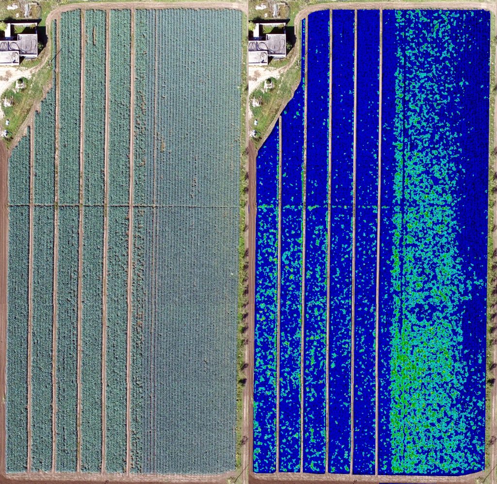
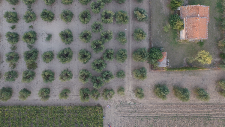
Example of analysis of a sown field. Although cultivation appears homogeneous, signal processing techniques show shortcomings in production. Precision agriculture makes it possible to intervene in order not to have “holes” in production.
With the terms “Precision Agrigulture” (PA) we mean that set of technologies that allows you to manage the variability of the cultivated field, giving each plant what it needs exactly when it needs it, without overdoing it. The goal is to maximize production, increase the quality of the same, eliminating waste with a consequent profit for the farmer and the environment.There is not just one type of PA, but the general principles are tailored to each field and each crop. There are two fundamental technologies within the AdP:
- the semi-automatic guide;
- the variable dosage.
In general terms, the expected benefits are:
- optimization of production efficiency;
- optimization and quality enhancement;
- cost reduction;
- minimization of environmental impacts.
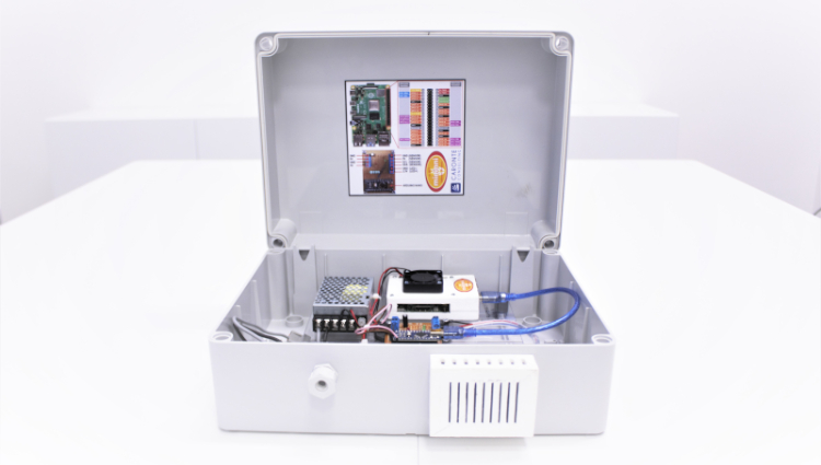
- Electronic devices , responsible for both data acquisition (monitoring) and the use of information within the production context (control);
- Positioning technologies , with which indispensable information is integrated when a spatial (or site-specific) dimension comes into play;
- Computer hardware , for the management and transmission of data (telecommunications networks and systems of various types);
- Software , for data processing and to make it understandable to end users.
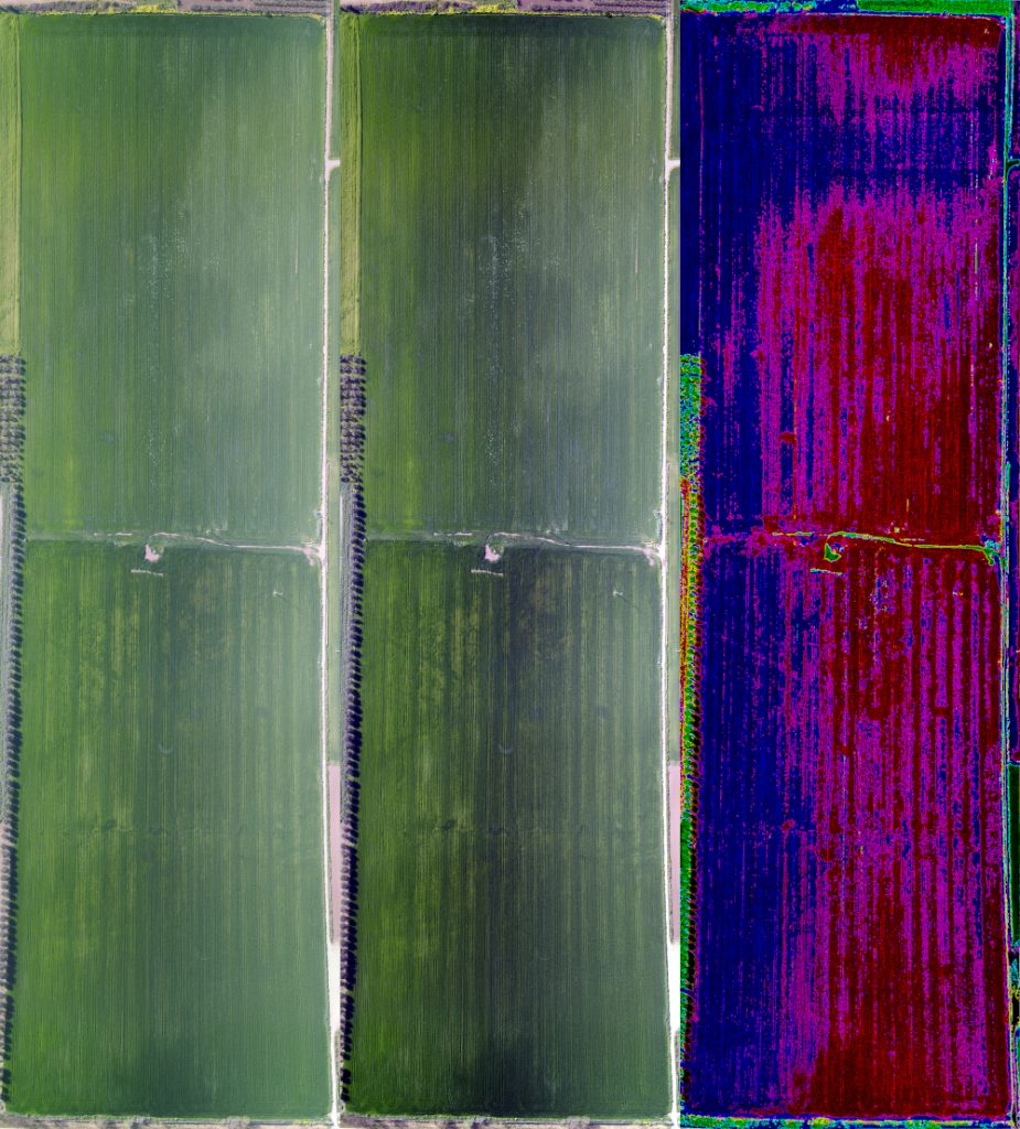
Example of a field ready for planting. The white traces show the presence of clay in the field.
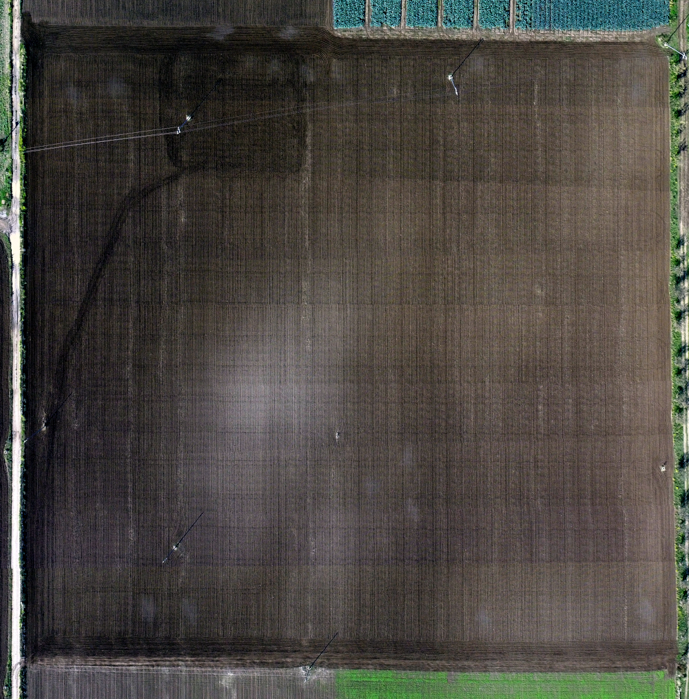
Example of analysis of the needs of a sown field. There are some washouts that prevent homogeneous production. As can be seen, the washouts processed with suitable tools take on a different dimension from the one made at a glance.
Scenario
The FAO estimates that by 2050 there will be a growth of the world population in about +9 billion people, consequently there will be an increase in the need for products and food needs of + 60% compared to the annual average analyzed from 2005 to 2007 (data Nikos and Bruinsma 2012). On the other hand, the acreage under cultivation globally will increase to a negligible extent. The Commission for Agriculture and Rural Development of the European Parliament confirms the data on the increase in the world population (McIntyre 2015).At the same time, consumers will demand better quality and healthier products in relation to increasing their food awareness (see our products on food safety ). The new challenge of agriculture will consequently be to produce more, in a more sustainable and above all in a healthier way.
REMOTE SENSING
Ground and drone monitoring
Caronte Consulting provides farms with various technologies to improve the management of their plots:
- control tools , which allow you to monitor and understand what is happening in the field through measurements (field surveys, soil analysis, weather stations, drone maps);
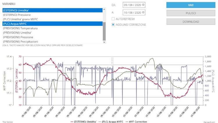
- forecasting tools , to estimate what will happen in the short future in the field (weather forecasts, estimation of irrigation or fertilizer needs, phenological and disease development models);
- actuation systems , which allow you to apply decisions at the field level (parallel driving, automatic driving, actuators, variable rate technology);
- deduction systems , etc.
Example of a system equipped with an autoguide dedicated to agriculture.
Surveying with drone
Maps and NDVI index

Monitoring devices
GPS-RTK surveying
Prevision systems
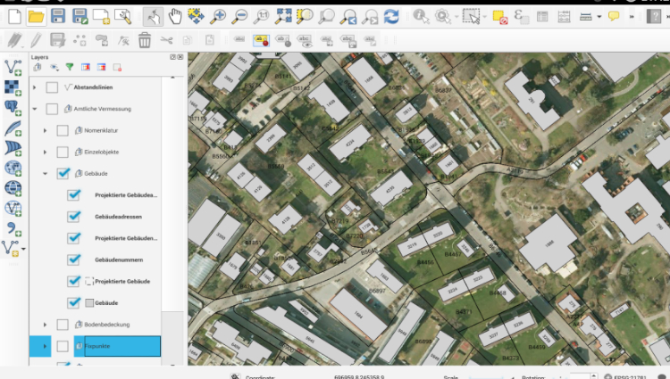
GIS system and georeferencing
Border surveying
Caronte Consulting makes itself available for the precision survey of borders with drone . This type of survey is performed by combining the drone with a survey carried out on the ground with a GPS-RTK system and the affixing of appropriate markers on the ground.The GPS-RTK system allows an accuracy that can extend up to 2 cm along the XY axes (Easting and Northing) and up to 4 cm along the Z axis (elevation). The term RTK (Real Time Kinematic) indicates a method that corrects the GPS signal in real time, significantly improving it, as the GPS signal for civilian use has an accuracy of about 1 meter.The acquired images are georeferenced in a GIS system and a georeferenced mosaic is composed. Third-party data useful for the purpose of the analysis are also loaded into the GIS system (eg cadastral maps, orographic maps, etc.). At this point, the required deductions and measurements are made.
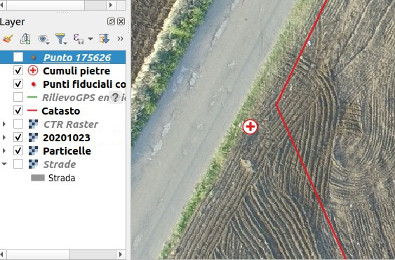
Details of a GIS system with layers of details superimposed on the georeferenced images of the drone.
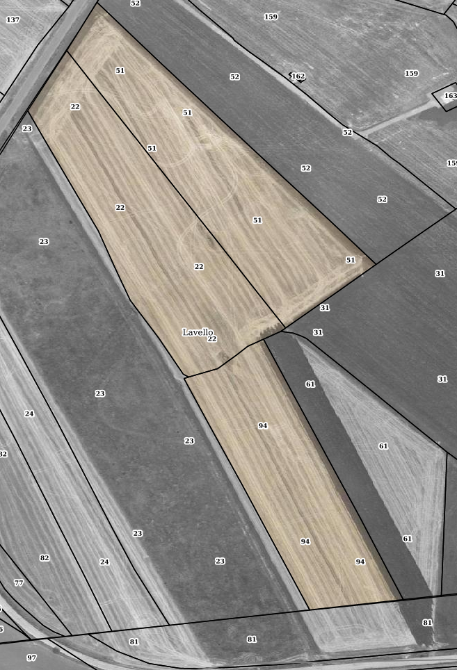
Example of a survey with drone whose images have been georeferenced with RTK technology and which are superimposed on the information maps of the regional cadastral system.
National guidelines
The use of new technologies contributes to obtaining a series of economic benefits and allows for a targeted distribution of the main production factors (water, fertilizers, pesticides) only where needed and in the required quantities through the use of sensors that allow monitoring in real time the state of health of crops, checking the onset of phytopathogens or unfavorable environmental conditions.It is for this reason that the Ministry of Agricultural Policies, on 1 September 2015, appointed a specific Working Group with the aim of investigating the issues relating to new technologies applied in agriculture and identifying actions to promote innovation in the sector. agricultural in the short and medium term.
Role of the institutions
Within the Guidelines, numerous fronts are identified on which the public administration can operate.On the subject of financing, rural development plans will above all collect the requests that will arrive from the territory to support investments by agricultural companies in the technology sector.The activity of the Ministry will continue to be of support and direction, also with the collaboration of other Bodies, such as Crea.